History
History of the Township
Township plans for its future.
Washington Township was organized out of Antrim Township by the Cumberland County Quarter Sessions Court in April of 1779. A petition for the division of Antrim had been presented to the Court at the preceding January term. The new Township, named after the then General Washington, took in more than half the area of the original Antrim Township, and included all of the territory which later became Quincy Township. The first settlements in the Township began as early as 1735 during the period in which Cumberland County was the western frontier of the colonies.
By 1768 the construction of a road extending from what is now Fulton County, eastward toward Baltimore, was authorized by Cumberland County. Originally built as a shipping route for flour produced locally, the road developed into a turnpike, and is the basis for what is now known as Route 16, or Buchanan Trail. Washington Township developed slowly during the early 19th Century.
However, between 1880 and 1890 the Borough of Waynesboro exhibited an increase in growth, and in the southeast corner of Washington Township there was a flourishing summer resort area. During this period, excursion trains came to Pen Mar Park which featured amusements and an outdoor dancing pavilion. Guests would stay at large summer hotels which had been built in the area. Luminaries of the time, including government dignitaries such as President Wilson and Admiral Dewey were frequent visitors to this attractive mountain resort area.
During the Second World War, this area was taken over by the United States Army, and a decline in the resort activity began. The era of summer mountain resorts had ended in Washington Township, and one by one, the hotels were converted or demolished. The last and one of the finest, the Buena Vista Springs Hotel, burned to the ground on December 8, 1967. It had existed for some 77 years and had contained 250 rooms on five floors.
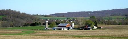
Washington Township is still oriented, to a great extent, toward agriculture including fruit and dairy production. Of course, increasing suburban growth has occurred, and later population studies illustrate periods in which the growth of the Township was significant. Even in the context of the modern developments, however, the Township is still largely dependent on other parts of the region for jobs and shopping, with commuting for both purposes, occurring to the Hagerstown and Chambersburg areas and, of course, to the Borough of Waynesboro.
Physical Characteristics and Resources
Although the physical characteristics, to a large extent, control people’s activities, it is also true that they must be carefully used and conserved. Our resources are not unlimited. Many of them, like mineral resources, once used, can never be re-established. Others, like ground water when polluted, take long periods of time to be rehabilitated. Also, it should be pointed out that the physical environment is not the only factor to consider. Economic and social factors are equally important.
For example, land which has good agricultural qualities is often ideal for many urban uses. In such instances, development decisions must be made on the basis of all the factors. In this context it becomes obvious that the great cycle, which is our environment, can and must be utilized to serve humanity, but it also must be used prudently so that the cycle is not permanently altered. In particular, this study will concern itself with the land and its form or topography, its content in terms of soils and geology, and its functional quality for a full range of potential uses.
Background of Physical Features
The major portion of Washington Township lies in an area known geologically as the Great Valley, or locally known as the Cumberland Valley. This valley runs Northeast to Southwest and is flanked by the South Mountains to the east and the Tuscarora Mountains to the west.
Topography of the Township is characterized by two ridges which cross the Township in a northeast, southwest direction. One of the ridges underlies the Borough of Waynesboro and is composed of a gently sloping topography with the vertical variation in elevation of approximately 350 feet. The other ridge borders the eastern edge of the Township with a relatively steep mountainous topography varying some 1,100 feet from the lowest point to the highest. The total elevation extreme in the Township ranges from a high point of 1,837 feet in the northeast corner of the Township in a portion of the South Mountains known as Virginia Rock, to a low point of 540 feet above sea level in the south central portion of the Township where Antietam Creek flows across the Mason-Dixon Line into Maryland.
The valleys of the Township are generally wide. The level areas with gently rolling topography have been virtually totally utilized for farming purposes. The topographic features shown in an early Comprehensive Plan on a map entitled, “Slope Map” indicate that some forty-nine percent of the land in Washington Township has topographical characteristics which make it highly attractive for development. An additional forty-three percent of the land in the Township may be used for development with some site work and with some construction problems. Therefore, approximately ninety-two percent of Washington Township is topographically usable for development.
Geology
Most of Washington Township is under-laid by limestone formations, and many of the rocks in the Township reveal varying degrees of iron, manganese and many non-metallic resources. In the area immediately adjacent to the South Mountains, there are numerous quartz veins, some of which may be of commercial value. Limestone and quartzite have been used for building stone throughout the Washington Township area, and red rhyolite, peculiar to the Washington Township area, has also been used for limited building in the past. Greenstone, which is associated with rhyolite, is useful for some building purposes; however, this stone is being quarried and crushed for roofing granules in adjacent Adams County. Reserves of this mineral are quite significant in Washington Township.
Drainage
Three major streams, the East and West branch of Antietam creek, and Red Run, form the major drainage areas of Washington Township.The western quarter of the Township drains into the West branch of Antietam Creek from its origin in Quincy Township, flowing along the Western border of the Waynesboro limits southward toward Washington County, Maryland. Both the East branch of the Antietam Creek and Red Run originate in the South Mountains and flow generally Southwesterly toward a junction with the West branch near the state line.Several minor streams, including Mackey Run and Devils Run, are fed by springs in the state forest area before interception by Red Run.A secondary drainage basin is formed by Falls Creek which joins Red Run southwest of Rouzerville. This stream is also spring fed and begins near Buena Vista. The earlier Comprehensive Plan illustrates the streams and drainage areas on a map entitled “Slope and Drainage”.
The presence of the state forest allows for the protection of watersheds for any municipal reservoir as well as the option for a municipality to lease and build a reservoir. The Bureau will not allow any activities in the watershed which will reduce the quantity or quality of water. If needed, the quantity of water can be increased to meet rising demands.